Geospatial and Land Surveying Services
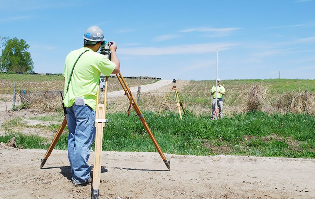
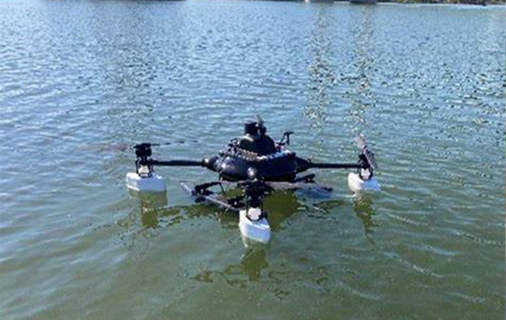
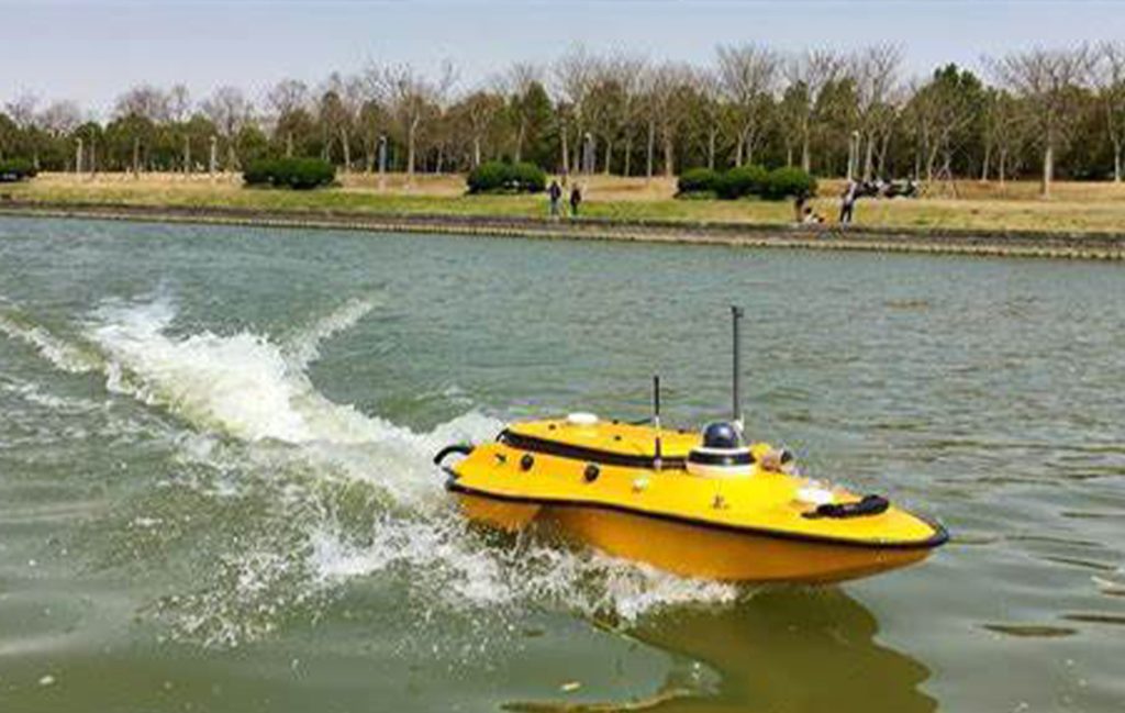
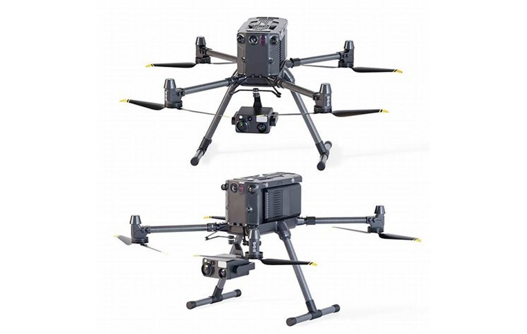
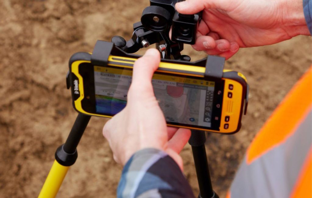
To ensure a comprehensive and fully integrated approach, we offer a full suite of surveying services across three key domains: aerial, land, and hydrographic surveying, utilizing recent technology and advanced equipment, including the DJI Matrice 350 RTK Payload Combo, which captures high-resolution imagery and LiDAR data for extensive remote areas or large-scale projects in a short timeframe. Additionally, we offer a wide range of land surveying services, including geodetic, topographic, engineering, cadastral, and control surveys, using advanced equipment such as the Leica Geosystems Total Station, Leica GS18 T GNSS RTK Rover, and CHCNAV AlphaUni 20 LiDAR. Furthermore, utilizing the Apache 3 Pro USV (Unmanned Surface Vessel) enables precise mapping and analysis of inside water bodies. WANDA SPHERE specializes in topography, land, roads and utilities, high-density surveying by 3D laser scanning, drone surveying, photogrammetry, GIS, geomarketing, single-beam / multibeam bathymetry, geophysics, launching, tidal and current measurements. The services offered by the office have been based, since its inception, on the latest advanced technologies and the most up-to-date methods and procedures in the field. This is a result of the expertise, qualifications, and commitment of the office's management and staff. With solid experience and unwavering professionalism, we ensure the quality of our services and rely on our expertise to meet the needs of our customers.
Topography and Geodesy
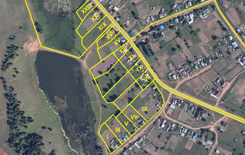
Our Topography and Geodesy services encompass applications and all studies or operations necessary to establish plans and related documents related to geodesy, cartography, topography, cadastral surveys, and land expertise at all scales, including delimitation of real estate, co-ownership, and subdivisions. As well as all survey and installation operations (railways, roads, crossroads, ONCF lines, networks,…) relating to land consolidation, land use planning, buildings and public works (concealment of structures and stability control, longitudinal and cross-sections, cubature calculations, etc.)
- Cadastral consultations;
- Search for and re-establishment of boundary markings;
- Parcel surveys;
- Delimitation of easements;
- Establishment of technical files for updating land holdings, according to cadastral standards;
- Establishment of technical files for updating BI/IFE properties;
- Establishment of technical files of co-ownerships according to cadastral standards;
- Divisions and fragmentation of properties; Partition of real estate;
- Topographical plan: survey of the existing structure (interior and exterior)
- Dimension plan Location map
- Sharing Plan Plot plans
- As-built drawings Alignment orders
- Monitoring of the construction work of residences and housing estates; Control of locations, control of levels and boundaries;
- Land expertise;
- Feasibility studies for the realization of real estate and/or tourism projects.
- Delimitation of real estate, land expertise, co-ownership, and subdivisions;
Road and Miscellaneous Network Study
Study of roads and various networks concerns road studies and its infrastructures, more specifically roads and various networks, which include a certain number of networks with a road as well as their coordination over time. A distinction is made between the following:
Design and supervision of works: project manager,
Establishment of APS specifications
Follow-up of the implementation on the site.
Urban planning
Study and calculation of earthworks; Road study
Study of the sewerage network
Study, diagnosis and estimation of works related to the burial of overhead networks, Telecom, and Public Lighting;
Study of the telephone network
Study of drinking water supply,
Study of all off-site networks
Study of the sizing and installation of wastewater treatment plants (WWTP);
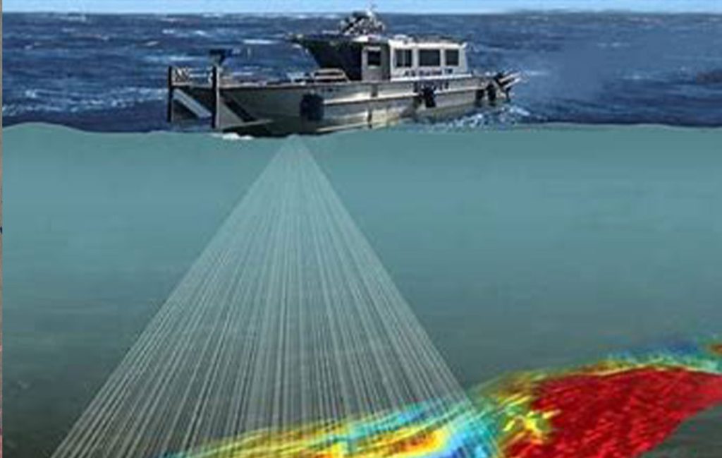
- Single-beam and multibeam bathymetric survey: ports, marinas, basins, rivers, rivers, dams, etc.;
- Monitoring of dredging work: quality control of dredging work, (Calculation of dredging volume, calculation of over-dredging, etc.);
Control of the depths of ships’ navigation access channels (establishment of profiles along and across access channels);
Establishment of bathymetric plans Control of port development works
Technical support for navigation (verification of the seaway and access to ports and marinas);
Positioning and location of beacons (DGPS technology);
Measurement of currents and tides (ADCP and Tide Gauge) Nautical Charting;
Setting up and timing tidal measurement systems
Geotechnical studies (underwater prospecting, determination of the nature of sediments on the seabed, etc
Current Measurement and Tide Measurement
Current measurement, tide measurement services concern:
Setting up and timing tidal measurement systems
Determination and control of the chart datum
Tidal measurements
Current velocity measurements,
Current direction measurements
Tide gauge studies
- Marine and terrestrial geophysical studies;
- Acquisition and interpretation of the characteristics of the underwater morphology with determination of the thickness of the different units;
- Acknowledgment of the nature of the funds; Geophysical imaging of the subsurface;
- Establishment of bedrock plans;
- Lance sounding and sample collection;
Geographic Information System (GIS)
A Geographic Information System (GIS) enables the retrieval of data in space, allowing for its synthesis, which is useful for informed decision-making. This is done using vector data (points, lines, polygons) or Raster Data (images: TIF, JPG, PNG, …). It makes it possible to represent, analyze, collect, process, model, store data and create new databases for the production of new maps.
Georeferencing maps
Digitization of geographic data (digitization/vectorization)
Geoprocessing
3D analysis
Spatial interpolation
Business Intelligence GIS
Producing maps to help with decision-making
3D Imaging and Scanning
The result of a 3D laser scanner scan is a set of millions of 3D points (XYZ) representing the surface of the object being surveyed: “Point Cloud”. From this, we proceed to the 3D reconstruction of the object in a very precise way with a real or colored texture. An important decision-making tool, its speed and accuracy are well established. Equipped with an innovative and high-performance hardware package, our services in this field are as follows: Precise surveys of assets, buildings, villas, cranes, etc.
Accurate modeling of buildings and other structures from the “Scan to BIM” point cloud;
Precise expertise of structures for the detection of degradation or anomalies;
Combination with multibeam bathymetry for the complete and precise regeneration of port structures (submerged and emerged parts);
Site monitoring;
Stock monitoring;
Calculation of cubatures;
Careers;
Tunnels;
Aerial Drone Shooting
Aerial photography involves capturing images of a territory from a drone to provide an overview. A stereoscopic shot enables the reproduction of all objects in three dimensions. It is a new relevant technology in view of its performance, speed of execution, accuracy, and rendering of information to allow:
Digital Terrain and Surface Model (DTM and DSM);
Continuous digital orthophotography;
Orthophotos-plans in color with cartographic design; Restitution plans;
Panoramic photos;
Institutional video established according to a video capture scenario;
Aerial drone shot.
Cadastre
We bring together expert surveyors and technicians specialized in the field of land works and topography. The importance of these resources enables us to ensure responsiveness and quality while adhering to the set deadlines. Our various services concern:
Cadastral consultations;
The search for and re-establishment of boundary markings;
Parcel surveys;
The delimitation of easements;
The establishment of technical files for updating land properties, according to cadastral standards, BI/IFE properties, and co-ownerships according to cadastral standards;
The divisions and subdivisions of property;
The division of real estate;
Monitoring the construction of residences and housing estates;
Siting control, control of levels and boundaries in accordance with the urban code and master plans;
The establishment of plot plans and as-built plans; Land expertise;
Feasibility studies for the implementation of real estate and/or tourism projects.
The delimitation of real estate, land expertise, co-ownership and subdivisions.
BIM
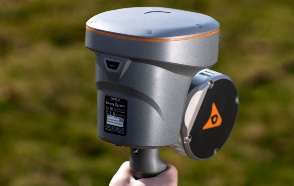
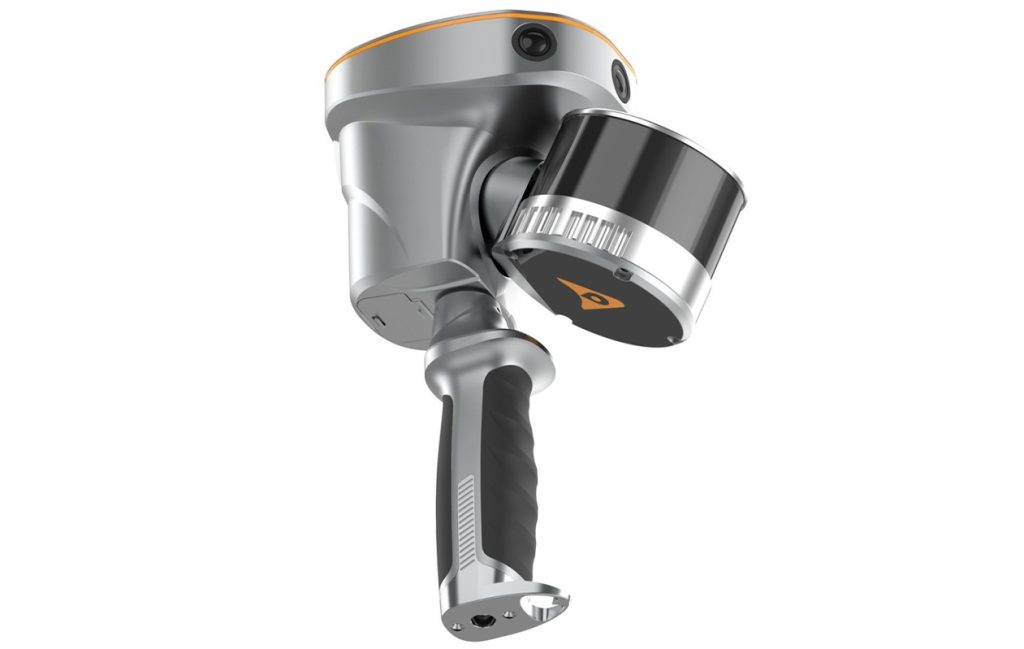
We use an intelligent 3D digital model for a construction project. This is supported by using tools like the CHCNAV RS10 Handheld SLAM 3D Laser Scanner with GNSS RTK to capture precise 3D data of existing infrastructures or environments. This data is then imported into a modeling environment to generate highly accurate, reality-based 3D models. The RS10 is widely applied in surveying, construction, BIM, industrial inspection, and other fields requiring accurate 3D spatial data.
BIM (intelligent 3D digital model) modelling of sites, buildings, real estate complexes, etc.
Topographical surveys of the existing Digitization of plans,
Qualification of the information entered into the database,
Development of tools for managing your real estate assets.